Katrina: The Geography of What HappenedKatrina: The Geography of What Happened
|
![]()
![]()
![]()
New Orleans was built on land that resembles a bowl, so that much of the city lies below sea level up to a depth of 10 feet. Surrounding this land are several bodies of water that all lie several feet above sea level. The Mississippi River's surface is normally about 11 feet above sea level. Lake Pontchartrain, on the city's north, lies about 2 feet above sea level at its normal stage. Lake Borgne, on the east side of St. Bernard Parish, is an embankment of the Gulf of Mexico and therefore is normally at sea level. To keep the river and the lakes within their banks, the Corps of Engineers artificially heightened the natural levees built by these bodies of water over the course of several thousand years. The Corps also built a system of flood walls to top all of the levees. The flood walls also surrounded the canals that reached into the heart of the city from Lake Pontchartrain. All total, the city was protected to a height of approximately 20 feet above sea level on the river and approximately 15 feet above sea level on Lake Pontchartrain.
New Orleans was never able to rely on gravity to drain the land on which it sat. Every drop of water that entered the city, either from the sky or its surrounding bodies of water, had to be artificially pumped out. In order to do this, the Corps of Engineers built a system of canals and pumping stations. Excess water drained into the sewer system much like the drainage system of any other city. However, from the sewer system, the water was pumped into the drainage canals located throughout the city and its suburbs. Finally, the water was pumped into Lake Pontchartrain. This system had served New Orleans well for most of the 20th century. As long as the river did not reach a flood stage of 20 feet, or the lake flooded at 14 feet, the city was safe. However, the city of New Orleans remained vulnerable. Should the complicated system ever fail, or be faced with more water than it was capable of handling, the city faced the possibility of being inundated.
Hurricane Betsy hit New Orleans in 1965, flooding the city in the worst flood since 1927. Most of the damage and deaths in Louisiana following Betsy (76 in all) were caused by the flood from Lake Pontchartrain. After Betsy, the natural levees along the river and Lake Pontchartrain were improved by the Corpse of Engineers. They were heightened and their bases were fortified with rocks and concrete blocks. However, the Corps made it clear that these improvements would only protect the city from a direct hit by a category 3 hurricane. Federal and state officials were made very aware that a direct hit from a category 4 or 5 hurricane would be fatal for the city. Because of this, the Federal government was lobbied heavily to provide the funds to improve the levee system as well as the canal and pumping station systems so that the city could withstand such a powerful storm. However, by the time Betsy hit, the United States found itself devoting more and more time and money to its obligations in Vietnam. Funds were not committed to make the improvements needed. By the time the war was over, the threat from hurricanes as demonstrated by Betsy was no longer on the minds of most people. Meteorologists, however, kept the pressure up as much as they could. By the 1980s, the primary concern for Federal spending was military defense. In the 1990s, the concern was the war in the Persian Gulf and Middle Eastern security. Finally, following September 11, 2001, the Terrorism wars took precedence. In spite of the warnings from local and state officials, meteorologists, and other scientists, the threat to New Orleans remained a secondary concern of the Federal government. “Homeland Security” did not include the threat to the nation from the environment. Each year since 1965, the city was forced to play a game of Russian Roullette with nature. Amazingly, each year the city won this game. Its luck ran out, however, on August 29, 2005.
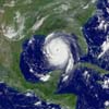
Hurricane Katrina was a category 5 hurricane that was spawned in the warm waters of the western Atlantic Ocean southeast of the Bahamas. The disturbance (Tropical Depression 10) that eventually became Hurricane Katrina was very slow to organize. In fact, it had died out before merging with another system. The new system was given a new designation – Tropical Depression 12 – and was christened Katrina when it grew into a tropical storm. By the time it arrived on the southeastern shore of Florida it was a Category 2 hurricane. As it made its way across the Florida peninsula it quickly lost strength and was downgraded to a tropical depression.
As the storm entered the waters of the Gulf of Mexico it was greeted with some of the warmest waters ever recorded in the Gulf. Warm water is like a vitamin pill for hurricanes. Within only hours of reaching the Gulf it regained hurricane status as it began its westward track. Even seasoned meteorologists were amazed at how quickly the storm fed on the warm gulf water. Within three days, the storm had become the fifth most intense Atlantic basin hurricane ever recorded. It’s greatest sustained winds were clocked at 185 mph with gusts of 215 mph. The minimum air pressure at its center was recorded at 902 millibars, one of the lowest pressures ever recorded. It was clear to meteorologists that a major storm threatened the United States. What was worse was the storm’s size. This was a hurricane that covered about 90% of the entire gulf basin with its cloud cover. Hurricane-force and tropic storm-force winds extended from the storm’s eye for over 200 miles in either direction. It was clear that when the storm made its second landfall it would affect not just a local area but an entire region.
Shortly after Katrina entered the Gulf of Mexico, forecasters made a prediction about the storm’s track. Though it was traveling in a fairly westward direction, computer models showed that it would make a northern turn. Originally meteorologists predicted landfall along the Florida panhandle. However, as the storm continued to travel westward, the prediction was moved westward to Mississippi or Louisiana. In fact, most models predicted a bulls eye on New Orleans. This prediction led to the first mandatory evacuation order in the history of the city. Those who could heeded the warning. Those who couldn’t – mainly the poor who comprised over 60% of the city’s population, lacking cash and transportation out of the city – prepared to hunker down in their homes. Many went to the only shelter made available to them in the city, the Louisiana Superdome.
The storm made the predicted turn to the north. As the hours wore on, it became clear that the computer models that targeted New Orleans were correct. Few forecasters doubted that New Orleans would not receive a direct hit. As the storm grew and strengthened, first to a Category 3, then a 4, and finally a Category 5, the city prepared as best it could, knowing very well that it could not sustain the onslought of such a storm. The mayor of New Orleans assured those who stayed in the city that the Superdome would be a safe place for the stranded population to ride out the storm. All the city had to do was ride out the storm and the government and other relief would soon be in the city after the winds subsided. After all, the Federal government had been made well aware over the years what would happen if such a storm hit New Orleans.
Hurricane Katrina made landfall shortly after 6:00 am on the 29th of August. Hurricane-force winds reached the city over night. Though the storm had been a Category 5, it weakened to a Category 4 just before its landfall. This is a very typical phenomenon for hurricanes. In addition, the storm wobbled slightly so that it did not directly hit the city. The storm shifted to the east slightly and made a second landfall along the Mississippi coast, putting New Orleans on the storm’s western side. Ordinarily, this is a good place to ride out a storm such as Katrina. The western side is normally the weakest side of hurricanes. It appeared that perhaps New Orleans had dodged a close one yet again. However, things began to unravel very rapidly following landfall.
 |
| Click thumbnail to see larger image |
 |
| Click on thumbnail to see larger image |
Direct damage caused by Katrina stretched from Mobile, Alabama to Lafayette, Louisiana and from Miami, Florida to Jackson, Mississippi. Tornadoes spawned by Katrina damaged areas from Mississippi to Pennsylvania. Over 1000 people died during the destruction. However, as widespread as the destruction was, the center of the devastation lay squarely in New Orleans.
This explains in geographical terms what happened to New Orleans following the worst natural disaster in the nation’s history. What followed the natural destruction of the city is the expertise of sociologists and political scientists. Though very little could be done to prevent the physical damage caused by Katrina, a great majority of the deaths that occurred were the result not of the storm itself, nor the resulting flood, but of the inequalities in New Orleans’ society and political indifference to the valid warnings of scientists to the dangers of ignoring nature’s threats. In other words, most of the people who died in Katrina’s wake were victims, not of the storm itself, but of human error.
![]()
![]()
![]()