Hurricane Katrina Impact Studies
Partial link and pictures copied from:
http://coastal.er.usgs.gov/hurricanes/katrina/photo-comparisons/chandeleur.html
.
Our barrier islands protect South Texas, Louisiana, Mississippi, Alabama, and the Florida panhandle.
Before and After Photo Comparisons:
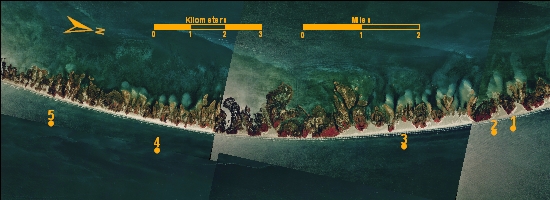
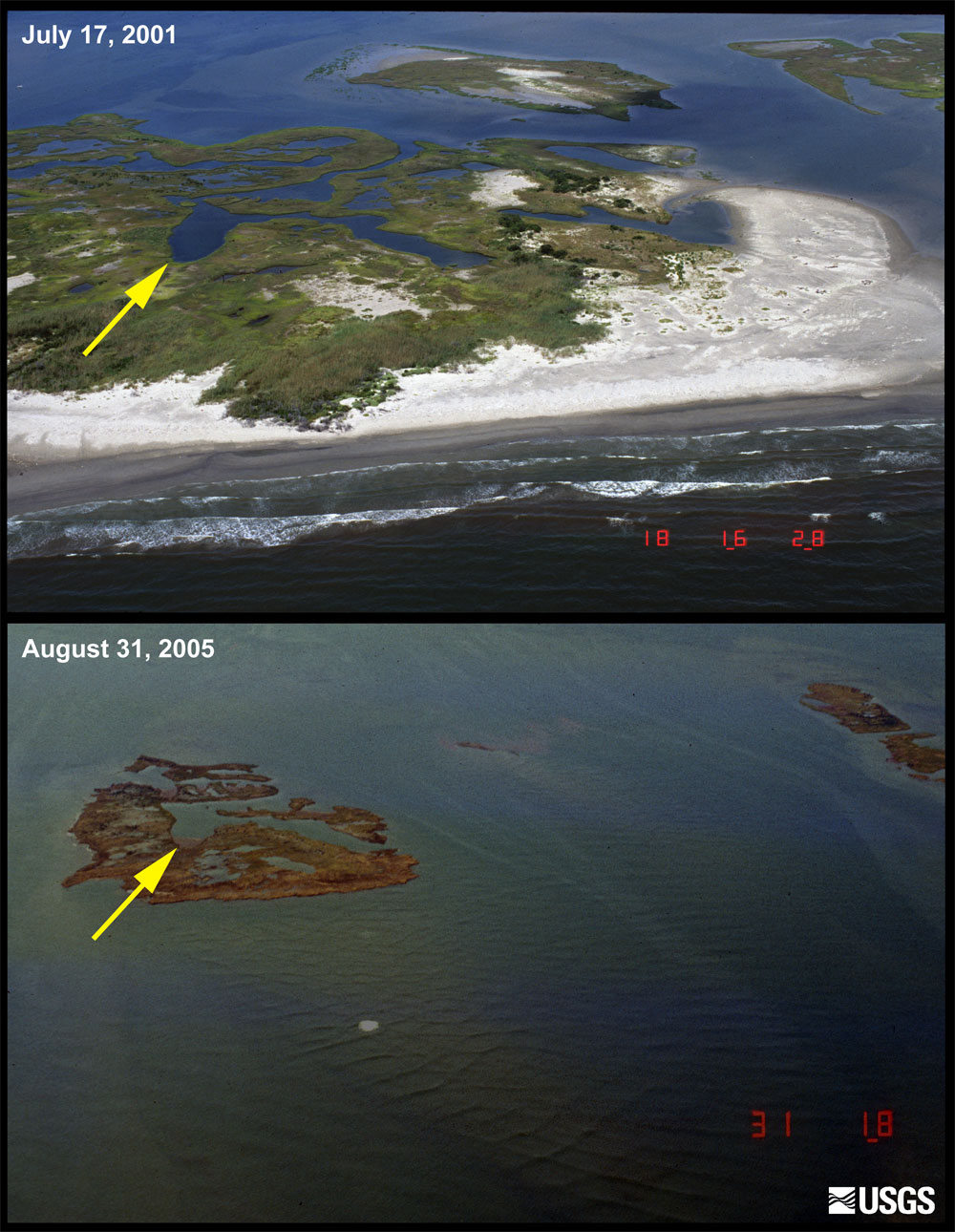
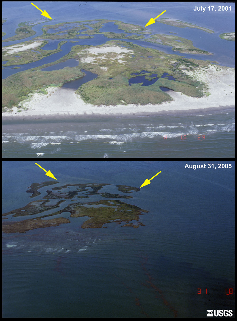
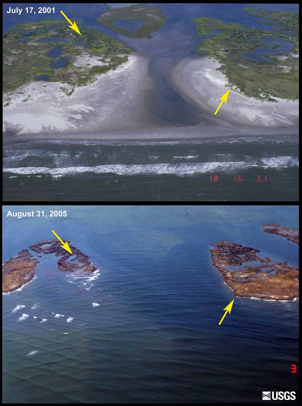
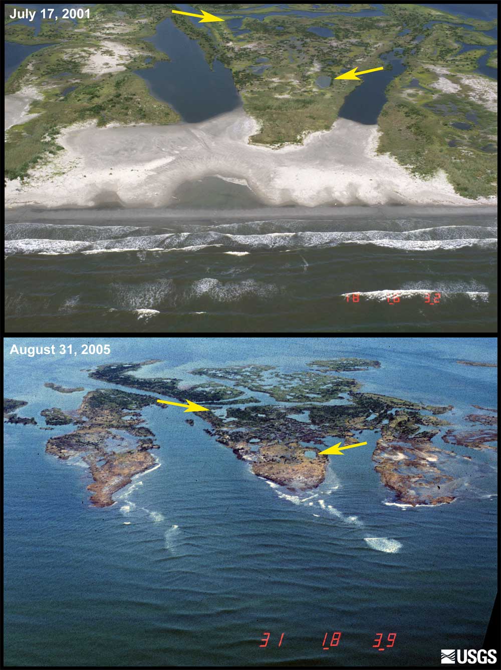
Chandeleur Islands
The Chandeleur Islands are a north-south oriented chain of low-lying islands located approximately 100 kilometers east of the city of New Orleans, Louisiana. Below, photo pairs reveal the nearly complete destruction of the islands in recent hurricane seasons. The first image in each pair was taken in July 2001, before Hurricanes Lili (2002), Ivan (2004), Dennis (2005), and Katrina (2005, the strongest and closest in proximity to the Chandeleurs). The second image was taken on August 31, 2005, two days after Hurricane Katrina made landfall on the Louisiana and Mississippi coastline.
Photo showing locations of pre-and post-storm photo sets. Scroll down or click on the yellow location numbers on the photo above to view the pre- and post-storm photo sets for the Chandeleur Islands.
Location 1: The first image, taken in July 2001, shows narrow sandy beaches and adjacent overwash sandflats, low vegetated dunes, and backbarrier marshes broken by ponds and channels. The second image shows the same location on August 31, 2005, two days after Hurricane Katrina made landfall on the Louisiana and Mississippi coastline. Storm surge and large waves from Hurricane Katrina submerged the islands, stripped sand from the beaches, and eroded large sections of the marsh. Today, few recognizable landforms are left on the Chandeleur Island chain. [larger version]
Location 2: The first image, taken in July 2001, shows narrow sandy beaches and adjacent overwash sandflats, low vegetated dunes, and backbarrier marshes broken by ponds and channels. The second image shows the same location on August 31, 2005, two days after Hurricane Katrina made landfall on the Louisiana and Mississippi coastline. Storm surge and large waves from Hurricane Katrina submerged the islands, stripped sand from the beaches, and eroded large sections of the marsh. Today, few recognizable landforms are left on the Chandeleur Island chain. [larger version]
Location 3: The first image, taken in July 2001, shows narrow sandy beaches and adjacent overwash sandflats, low vegetated dunes, and backbarrier marshes broken by ponds and channels. The second image shows the same location on August 31, 2005, two days after Hurricane Katrina made landfall on the Louisiana and Mississippi coastline. Storm surge and large waves from Hurricane Katrina submerged the islands, stripped sand from the beaches, and eroded large sections of the marsh. Today, few recognizable landforms are left on the Chandeleur Island chain. [larger version]
Location 4: The first image, taken in July 2001, shows narrow sandy beaches and adjacent overwash sandflats, low vegetated dunes, and backbarrier marshes broken by ponds and channels. The second image shows the same location on August 31, 2005, two days after Hurricane Katrina made landfall on the Louisiana and Mississippi coastline. Storm surge and large waves from Hurricane Katrina submerged the islands, stripped sand from the beaches, and eroded large sections of the marsh. Today, few recognizable landforms are left on the Chandeleur Island chain. [larger version]
Location 5: The first image, taken in July 2001, shows narrow sandy beaches and adjacent overwash sandflats, low vegetated dunes, and backbarrier marshes broken by ponds and channels. The second image shows the same location on August 31, 2005, two days after Hurricane Katrina made landfall on the Louisiana and Mississippi coastline. Storm surge and large waves from Hurricane Katrina submerged the islands, stripped sand from the beaches, and eroded large sections of the marsh. Today, few recognizable landforms are left on the Chandeleur Island chain. [larger version]
Evacuation
Wanderings
Levee Breaks
Levees
and
Breaks
Flooded Houses
UNO,
Ursuline, and
relatives houses.
Driving
Around
 
Do/don't like the site? Email me and tell me about it.
Cleaning up and some fun pictures.
Christmas around town
Link copied from southbear.com which describes very well why the flood was so bad.
JEMS - Excellent description of what went on from EMS' point of view..
UNO pictures
The islands (Dauphin and Chandeleur) that protect our coastline an southern cities.
Miscelaneous satellite pictures.
More Katrina pictures from WWLTV.com
More pictures found on the web.
Lakeview pictures during the flood mailed to me 3-3-06
Lakeview Revisited - Pictures 7 months after Katrina taken in March 2006
The surge out at Michoud from WWLTV.com
Doug's fly over pictures of Katrina's damage on our swamps and southernmost towns. March 2006
Back to the main Katrina map page