The following images were copied from WWLTV's (New Orleans) website.
http://www.wwltv.com/Katrina/index.html
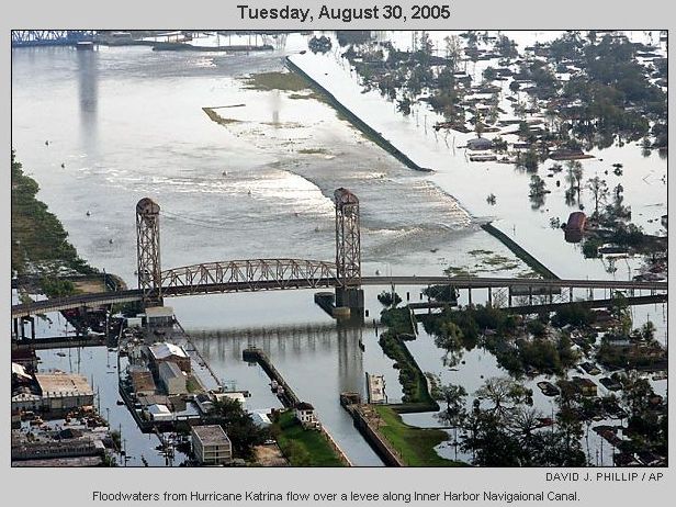
Main levee break on Industrial Canal by St. Claude Bridge. If you know where to look, the barge that floated through the levee is just inside the break near the bridge.


Evacuation
Wanderings
Levee Breaks
Levees
and
Breaks
Flooded Houses
UNO,
Ursuline, and
relatives houses.
Driving
Around
Wandering
Dogs
State Park
17th Street
London Ave
Mirabeau
St. Bernard
9th Ward
Levees
Chinooks
House #1
House #2
Satelite Images
UNO
Ursuline
Relatives
Driving #1
Driving #2
 
Do/don't like the site? Email me and tell me about it.
Cleaning up and some fun pictures.
Christmas around town
Link copied from southbear.com which describes very well why the flood was so bad.
JEMS - Excellent description of what went on from EMS' point of view..
UNO pictures
The islands (Dauphin and Chandeleur) that protect our coastline an southern cities.
Miscelaneous satellite pictures.
More Katrina pictures from WWLTV.com
More pictures found on the web.
Lakeview pictures during the flood mailed to me 3-3-06
Lakeview Revisited - Pictures 7 months after Katrina taken in March 2006
The surge out at Michoud from WWLTV.com
Doug's fly over pictures of Katrina's damage on our swamps and southernmost towns. March 2006
Back to the main Katrina map page